The Machu Picchu hiking trail is the most popular and well-known route among tourists. The trek has a total distance of approximately 43 kilometers and takes 4 days to complete, including a day of visit to the Archaeological Park of Machu Picchu. The surrounding nature is wonderful, with breathtaking views of snow-capped mountains, and the walk through the jungle with its amazing archaeological remains is an unforgettable experience.
It is undoubtedly one of the most popular excursions for those who seek adventure when visiting Peru, its spectacular landscapes of the chain of the Andes show a great mix of forest and mountains that you will enjoy from beginning to end.
There is no other natural circuit anywhere that leads to a natural world with changing ecological floors constantly adorned with towering snows, rivers and great fauna and flora. All these natural wonders are added to Inca constructions that are worth visiting, the architectural art harmonizes perfectly with the natural environment.
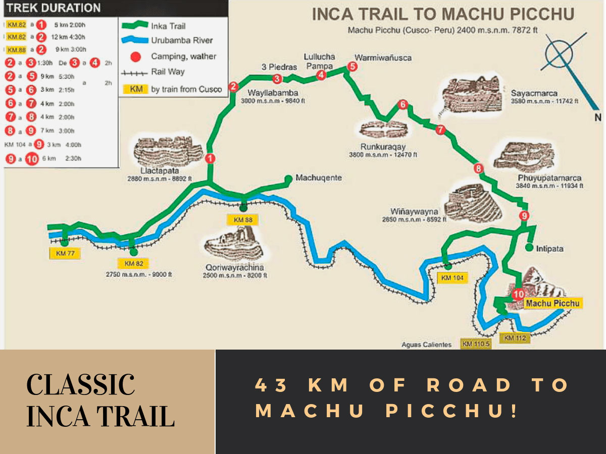
This classic Inca Trail can start at km 77, km 82, and km 88. At km 77, which is the town of Chillca, you can get there by bus. Meanwhile, at km 82 or km 88, you arrive exclusively by train. It is necessary to be very careful during the trip to the kilometric points and to warn with the time that you want to get off, otherwise the train will continue its journey.
The 4 day Machu Picchu Inca Trail is known as one of the best hikes in the world, not only for its history, but for the beauty of its natural surroundings. This route is a geographic journey that covers dramatically opposite ecological zones: from the dry and high deserts of the highlands to the vibrant humidity of the Andean tropical forests.
Following this ancient road system (Qhapaq Ñan) means passing through mysterious archaeological sites that appear in the mist and environments covered in wild vegetation. All the effort ends with the final reward: crossing the Sun Gate (Inti Punku) to have the first panoramic view of the lost city of the Incas, Machu Picchu.
Key facts you will see on the map:
Total distance: Approx. 43 km.
Highest point: Dead Woman's Pass (Warmiwañusca) at 4,215m.
Start: Km 82 (Piscacucho).
End:Machu Picchu (through the Sun Gate).
Day 1
The Traditional Inca Trail begins in the city of Cusco, from where they move by bus to km 82 or Piscacucho, from the point of control begin the adventurers to load the backpacks to start their adventure to Machupicchu at a height of 2650 masl, the ascent of the first day will be gradual and simple, they will climb only up to 3000 masl passing through Miskay (2800) and finally Huayllabamba (3000).
Day 2
The second day will pass through narrow and steep trails (9 km) uphill to reach the top of the Warmihuañuska mountain, then begin to descend to Pacaymayo 3600 meters above sea level, the walking time will be 6 hours.
Day 3
This day the hike begins with a slight ascent to Pacaymayo, from where a walk through a more difficult stretch begins for 1 hour until you reach the archaeological complex Runkuracay 3,750 masl, then a descent to a lagoon called Yanacocha and another ascent to Phuyupatamarca and finally an excursion through flat ecosystems to Winay Wayna.
Day 4
The last day of adventure will be calm, with a slight ascent until inti punku and a descent towards the citadel of Machu Picchu.

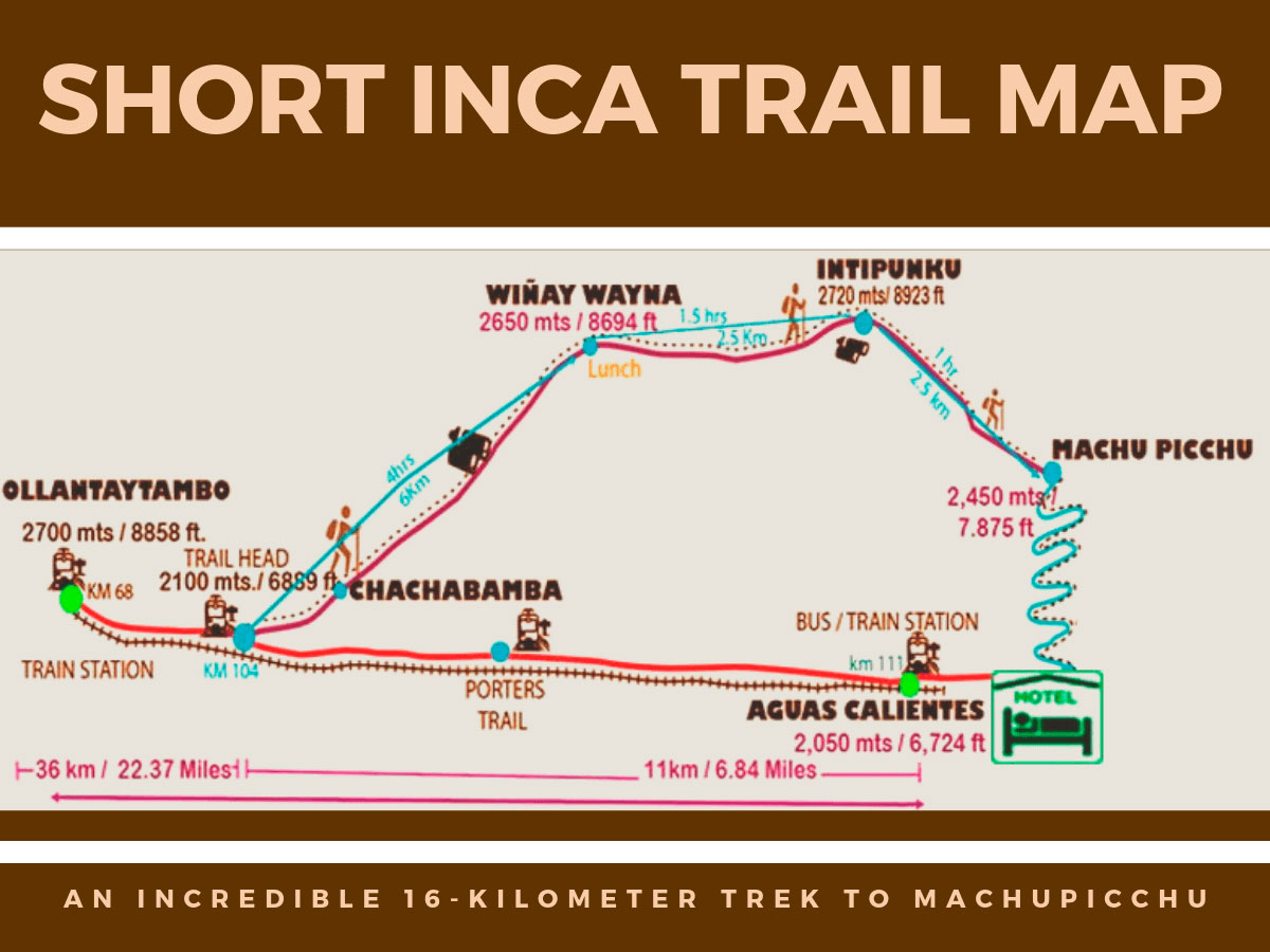
This compact version of the legendary path is ideal for travelers who have little time, but refuse to give up the magic of reaching the citadel on foot. Also known as the "Sacred Path", this route offers an amazing mix of landscapes in less time, letting you enjoy the change between the mountains and the jungle brow, an ecosystem famous for its variety of orchids and exotic birds.
The route starts at Km 104 and is a steady climb. On the map, the journey connects archaeological sites that overlook the Sacred Valley and look toward the Peruvian Amazon:
Key data you will see on the map:

Besides the famous Inca Trail, there are alternative routes that lead to Machu Picchu and offer unique experiences. These treks are ideal for those who are looking for a different route, direct contact with nature, and varied landscapes of the Andes. Among the most recommended are:
If you want to visit Machu Picchu, we recommend you to book your Machu Picchu Entrance Tickets in advance, so you will enjoy your Vacation in Machu Picchu without any problem.