
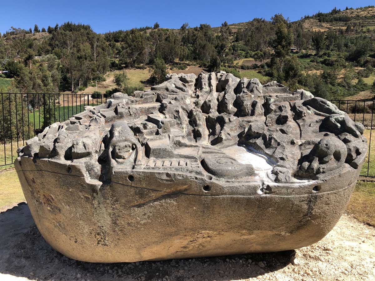
Sayhuite is one of Peru's lesser-known archaeological sites, but it holds one of the most intriguing monoliths of Inca culture: the Sayhuite Stone. Its exact function remains a mystery, but its complexity has sparked numerous theories. The great attraction of the place is a granite rock over 4 meters long and 2.5 meters high, carved on the upper part with more than 200 geometric and zoomorphic figures, among which felines, frogs, lizards, tunnels, channels, terraces, ponds, and stairs stand out. The relief seems to represent a complete hydraulic system. Some researchers believe it was a model to test irrigation projects. Others think it was a topographical model of the Inca empire, where each region was represented with its characteristic fauna: iguanas or monkeys for the jungle, pelicans for the coast.
Everything indicates that Sayhuite was a ceremonial center linked to the cult of water. The place was surrounded by channels, fountains, and stone walls. Even carved blocks in the shape of thrones and stairs have been found, possibly part of a larger structure that has now disappeared.
According to the tradition collected by John Hemming, when the Spanish arrived at the site, they found that the temple was under the care of the priestess Asarpay. To avoid being captured, she threw herself from a nearby waterfall over 400 meters high. It is also said that the temple had walls covered with gold sheets the thickness of a hand.
Although no traces of that gold remain, the stone structures persist, many still covered by vegetation. Archaeologists have determined that the stone was modified several times. Channels were added and removed, which indicates that its use was active, possibly as a teaching or simulation tool for technicians in charge of hydraulic works.
The word Saywite comes from the convergence of two Quechua words which are: Sayay-Huiti, whose meaning in the Spanish language is "stop restless", while others say it is from Sayay-Ritti, whose meaning is "stop snow".
Sayhuite Stone is located in the district of Curahuasi, in the Apurímac region, about 47 kilometers east of Abancay and halfway between Cusco and Abancay. The site is nestled among green hills and bordered by two streams, in an area known as Concacha hill.
To get there, you must take the Cusco–Abancay road. From Cusco, the journey by land takes approximately 4 hours. It is advisable to hire private transport or join a tour that includes a guide.
The main area is on the high level, where the entire archaeological zone can be seen, here is the monolith in which it presents a varied iconography due to the profusion of sculpted elements on it, where you can see species of fauna that are not from the zone.
This representation is ovoid in shape whose height is 2.5 m, the lithic material is quite hard sedimentary rock. In the western sector of this monolith you can see several enclosures of various sizes, the largest is 0.5m by 0.7m; It has the shape of a pyramid and served as a dwelling for the priests.
It comprises a construction area whose characteristic is the succession of 9 sources with an orientation from east to west, with a stairway-archaeological-set-sayhuite-apurimac stairway in a number of sixty-eight steps, it presents a fine masonry delimited by two walls made from 0.6m by 0.4m tiles that served to celebrate the cult of water.
Located to the east of the complex, it comprises an area of ​​1200 m. This place is also known as Rumi Huasi and here is the monolith II with a cyclopean structure in a rectangular shape, the carvings are geometric (platform, stairs, circles, etc.).
Located in the south east sector, a solid structure called USNU PAMPA, 18 m. for 34 m. In this building, religious ceremonies of worship to the sun and water were carried out, constituting a place of mass concentration and worship of the god Sun and the Moon.
Characterized by the presence of the intihuatana monolith, being a rectangular Inca observatory element, its dimension is 3.40 m. 0.94 m wide and 0.94 m high, there is a complex of platform fountains associated with rooms where they controlled the time.

The Saywite stone, as previously described, is a huge granite block approximately 11 meters in circumference, 4 meters in diameter, and almost 2.5 meters in height. On its upper part, more than 200 figures carved in relief stand out, representing animals, plants, constructions, and geographical features of the ancient Tahuantinsuyo.
According to various studies, the stone symbolizes the Andean world. It has been interpreted as a three-dimensional map of Tahuantinsuyo, or even as an oracle or a ceremonial model representing the three regions of Peru: coast, highlands, and jungle.
The figures have been carved taking advantage of the natural shapes of the granite. Apparently disordered, these representations follow a logic that combines the natural environment with the Inca territorial organization.
In the lower part of the stone there are channels, wells, and passages that connect with other nearby structures. Some of them resemble sites such as Qenqo in Cusco or Vilcashuamán in Ayacucho.
The stone bears over 300 intricately crafted figures, depicting plants, animals, villages, and sacred geometry inspired by the Andean cosmovision. Some theorize that these figures served as maps of the region, while others suggest that the rock was a canvas for experimenting with architectural designs and planning for future constructions, including farming and irrigation systems.
However, there is a consensus among many that the primary purpose behind the creation of these ruins by the Inca civilization was to pay homage to water. This significance becomes evident when exploring another set of ruins situated just a few meters away from this ancient boulder—a water temple featuring sculpted terraces and a descending fountain that gracefully follows the contours of the hillside.
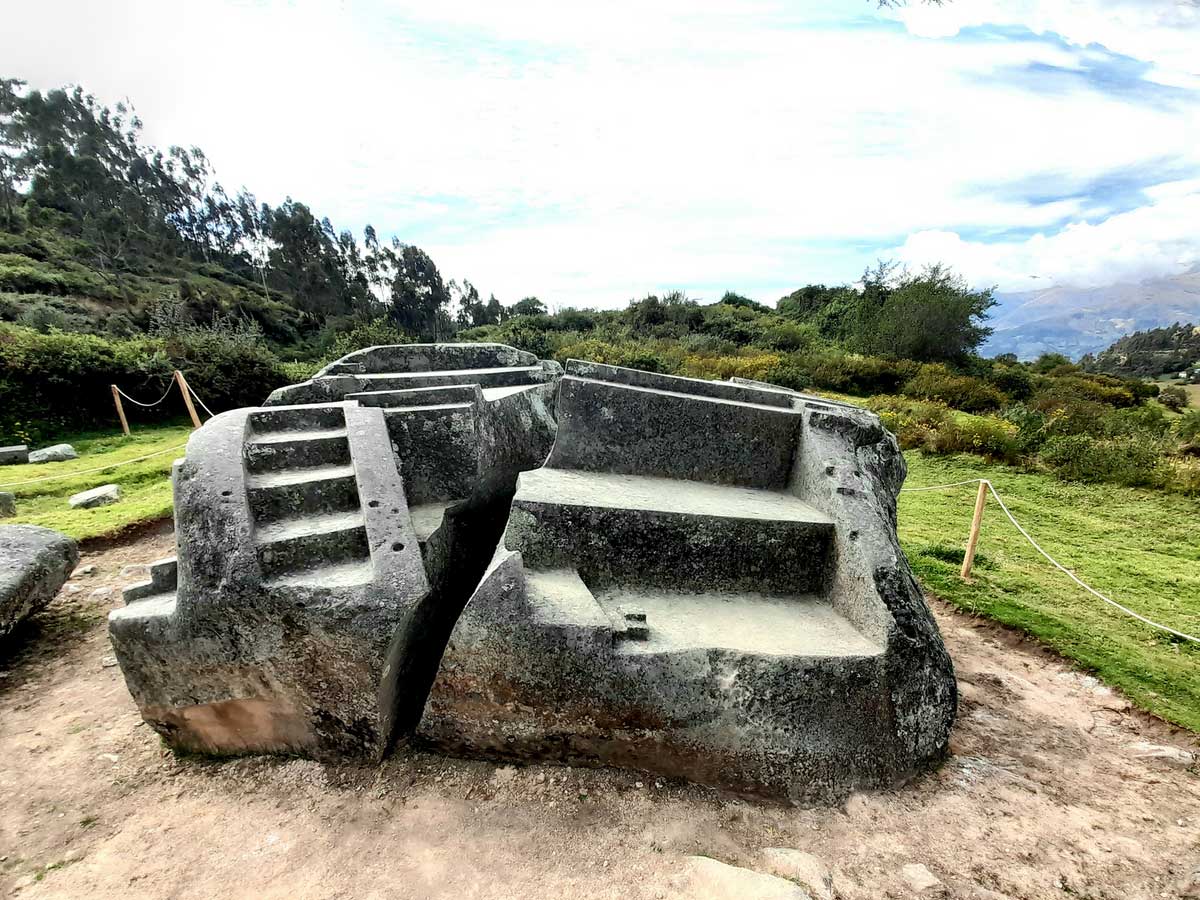
At about 300m you can see small monoliths such as Rumihuasi or a stone house with stairways, geometric lines, and canals. Intihuatana, finally finds the "Solar Clock" that was possibly destined as an observatory of astronomical movements.
Peru offers fascinating experiences that reveal natural landscapes, historical monuments, and living cultures, captivating those who seek adventure and discovery in every corner of its territory. Learn about some of the best trips you can take on your visit to Peru.
If you want to visit Machu Picchu, we recommend you to book your Machu Picchu Entrance Tickets in advance, so you will enjoy your Vacation in Machu Picchu without any problem.
 +51 84 217 551
 +51 997 434 941
 Av Tupac Amaru PP-10B, Santiago, Cusco, Peru
  info@incatrailmachu.com
 www.incatrailmachu.com


